This issue’s aerial photo by Sky Drone Aerial Photography gives us an unusual view of our distinctive and intricate waterways. What we see is Gerrans Bay, looking northeast. The foreground is busy with homes and docks, beautifully surrounded and interlaced with forest. You can see Cecil Hill and Mount Daniel ahead and a little left. The right foreground is a part of the extensive Francis Peninsula. The islands we see are Dusenbury and Tranquility Islands and in the distance, the Caren Range.
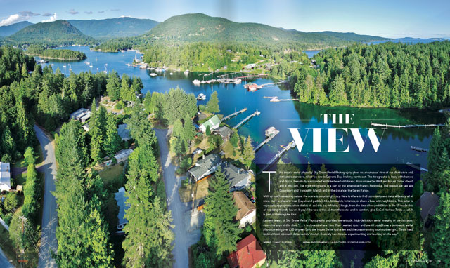
With so much sweeping nature, the scene is surprisingly cozy. Here is where to find community and natural beauty all at once. Here is where to boat (kayak and paddle), hike, birdwatch, botanize, or share a beer with neighbours. This latter is especially appropriate, since the locals call this bay Whiskey Slough, from the time when prohibition in the US made this an imbibing-friendly haven. If you’d like to see this all from the water and in comfort, give SloCat Harbour Tours a call. It is part of their regular tour.
Laurent Weiss of Sky Drone Aerial Photography provides low-altitude, high-definition aerial imaging of our fantastic coast. He says of this shot: “. . . it is close to where I live. Also I wanted to try and see if I could have a panoramic aerial photo covering over 230 degrees (you see Mount Daniel to the left and the coast running south to the right). This is hard to do without too much deformation/stretch. Basically I am forever experimenting and learning on the way.”
Words | Nancy Pincombe Aerial Photography | Laurent Wiese (skydrone.weebly.com)